

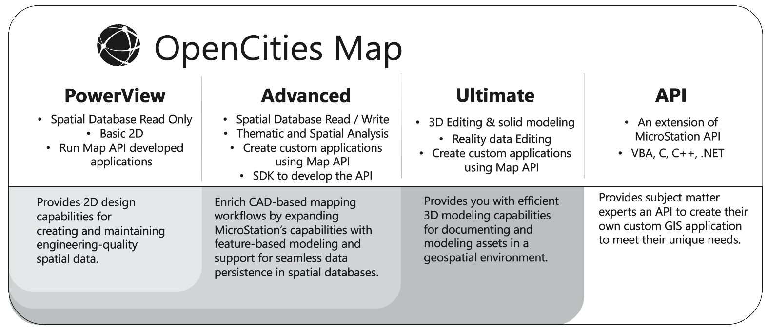
- OpenCities Map PowerView
-

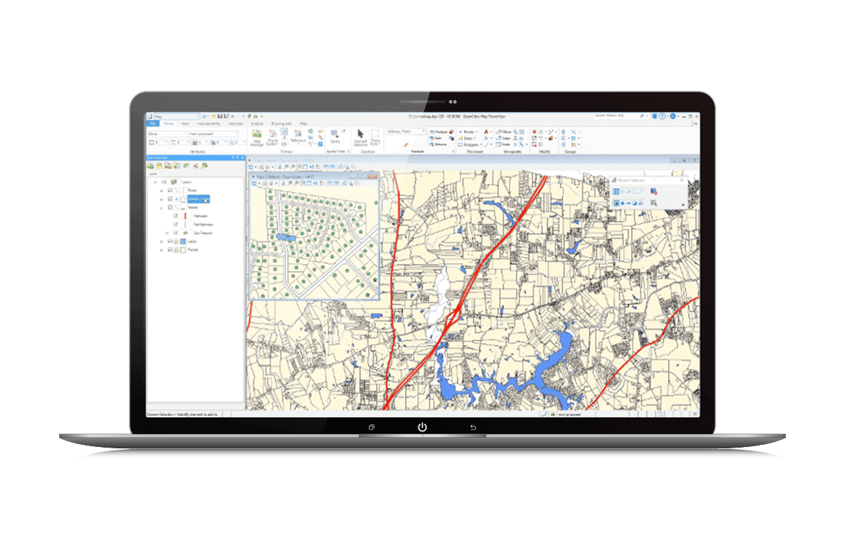
What is OpenCities Map PowerView?
OpenCities Map PowerView enables you to view map assets and perform light 2D feature acquisition and editing. It supports GPS and editing capabilities, making it ideal for field-based operations that require feature editing. It is an entry-level product to view and edit 2D geospatial information. OpenCities Map PowerView offers placement methods that convert CAD element creation tools into feature-based element creation tools. CAD users can continue to use familiar MicroStation capabilities to create feature-based map elements without learning a new workflow. You can also create in-house placement methods for more specific needs.
CAPABILITIES
Create Intelligent Geospatial Objects
Enrich CAD-based mapping workflows by expanding MicroStation’s capabilities with feature-based modeling. Customized placement methods could be created to accelerate design and avoid error.
Improved Interoperability
Direct querying of and imports from leading spatial databases (read-only) such as Oracle Spatial, Microsoft SQL Server, Esri File Geodatabase, ArcGIS Server & Online, PostgreSQL (PostGIS) and Web Feature Service (WFS), providing you with seamless and intuitive access to spatial data from a variety of sources. Integrates with the most common spatial databases and data formats.
Geospatial SDK Development Platform
Subject matter experts can create their own custom GIS application to meet their unique needs. OpenCities Map provides base geospatial functionality and database connectivity to build custom GIS solutions.
Better Geospatial Workflows
Easily edit and manage 2D data in a seamless workflow with quick streaming and direct data access.
Intelligent Geospatial Objects
Provides 2D design capabilities for creating and maintaining engineering-quality spatial data.
Unifies Spatial Information
Ensures data integrity and enforces business rules, as well as integrates geospatial information.
- OpenCities Map Advanced
-
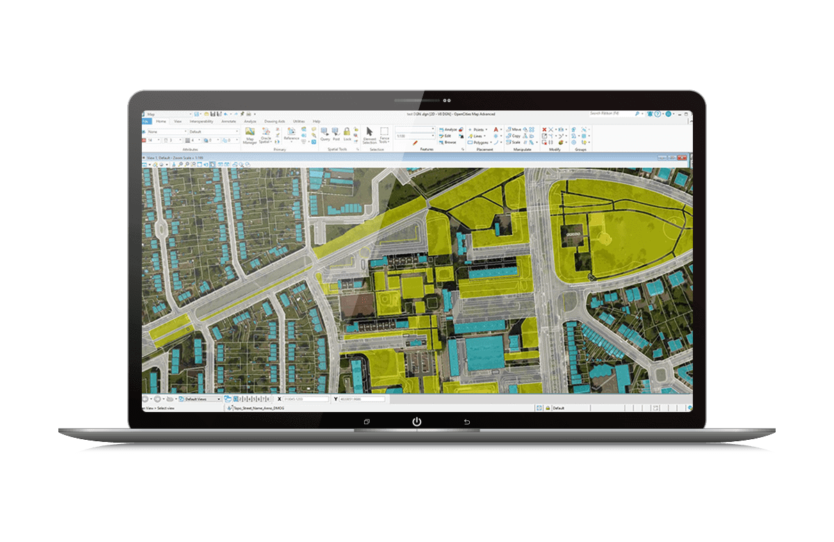
What is OpenCities Map Advanced?
OpenCities Map Advanced includes a rich set of capabilities that substantially increase productivity by enabling feature-based modeling workflows through its schema file. It allows you to define a set of features to be captured along with their related properties, symbology, annotation, and behaviors. By extending the MicroStation DGN format with XFM, OpenCities Map Advanced provides an environment that ensures geometric and business property accuracy while still allowing access to powerful MicroStation tools. OpenCities Map Advanced offers placement methods that convert CAD element creation tools into feature-based element creation tools. CAD users can continue to use familiar MicroStation capabilities to create feature-based map elements without learning a new workflow.
CAPABILITIES
Define a Feature Data Model with Business Properties
Rich set of capabilities that substantially increase your productivity by enabling feature-based modeling workflows through its schema file. The desktop software allows you to define a set of features to be captured along with their related properties, symbology, annotation, and behaviors.
Connect to the Most Common Spatial Database
Edit, maintain, and manage your 3D city model data including unstructured and structured data such as geospatial, architectural, and engineering designs, point clouds, and reality meshes. Seamlessly integrate with the most common spatial databases.
Customizable Feature-oriented Placement Methods
Convert CAD element creation tools into feature-based element creation tools. You can continue to use familiar MicroStation capabilities to create feature-based map elements without learning a new workflow. You can also create in-house placement methods for more specific needs.
Unifies 2D and 3D Spatial Information
Ensures data integrity and enforces business rules, as well as integrates geospatial information.
Preserve CAD Standards to Create Intelligent GIS Objects
Generates highly accurate spatial data for infrastructure workflows.
Increase Interoperability
Integrates with the most common spatial databases and data formats.
Accelerate Digital Maturity
Smartly convert CAD drawings into geospatial features and upload them in a spatial database.
- OpenCities Map Ultimate
-

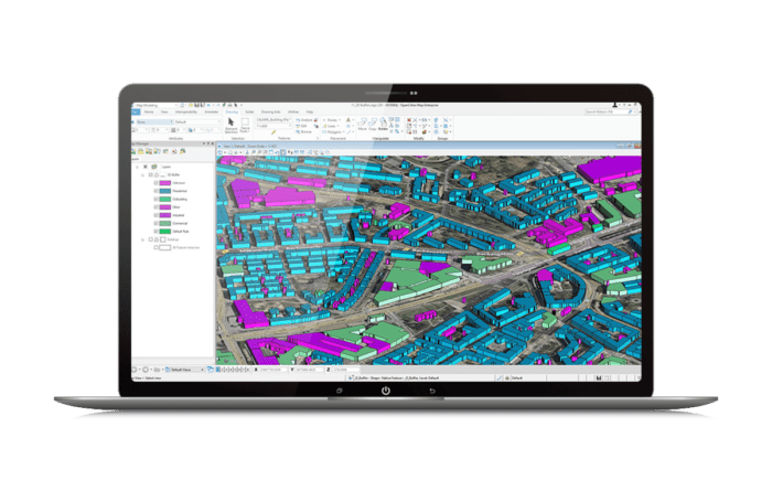
What is OpenCities Map Ultimate?
Full power of MicroStation, which includes all of the 3D editing and solid modeling tools, OpenCities Map Ultimate gives you access to a full collection of spatial analysis and presentation capabilities using 2D and 3D data. This includes the ability to create buffers around objects, perform topology overlays, create thematic 2D and 3D maps, detect 3D collisions, as well as capabilities to perform shadow and solar analysis. Work with reality data such as raster, STM, point cloud, and reality meshes to bring context to streamline workflows, simplify decision-making and ensure efficient project completion. OpenCities Map Ultimate provides high-level tools to work with reality data and extract information from it. You can easily add semantic information to 3D reality meshes using the classification feature.
CAPABILITIES
Integrate Reality Context
Integrate, process, and stream reality modeling data such as large-scale reality meshes, point clouds, scalable terrain models, and raster data for use in an engineering CAD environment along with a native spatial database connection.
Connect to the Most Common Spatial Database
Edit, maintain, and manage your 3D city model data including unstructured and structured data such as geospatial, architectural, and engineering designs, point clouds, and reality meshes. Seamlessly integrate with the most common spatial databases.
Create Intelligent Geospatial Objects
Work with 2D and 3D design productivity capabilities for creating and maintaining engineering-quality spatial data of city assets.
Better Integration of Reality Data into Geospatial Workflows
Work with reality data to bring context to streamline workflows.
Interconnect Engineering Data with the GIS Environment
Bring your engineering data within your GIS environment.
Increase Interoperability
Integrates with the most common spatial databases and data formats.
Accelerate Digital Maturity
Smartly convert CAD drawings into geospatial features and upload them in a spatial database.
What is OpenCities Map PowerView?
OpenCities Map PowerView enables you to view map assets and perform light 2D feature acquisition and editing. It supports GPS and editing capabilities, making it ideal for field-based operations that require feature editing. It is an entry-level product to view and edit 2D geospatial information. OpenCities Map PowerView offers placement methods that convert CAD element creation tools into feature-based element creation tools. CAD users can continue to use familiar MicroStation capabilities to create feature-based map elements without learning a new workflow. You can also create in-house placement methods for more specific needs.
CAPABILITIES
Create Intelligent Geospatial Objects
Enrich CAD-based mapping workflows by expanding MicroStation’s capabilities with feature-based modeling. Customized placement methods could be created to accelerate design and avoid error.
Improved Interoperability
Direct querying of and imports from leading spatial databases (read-only) such as Oracle Spatial, Microsoft SQL Server, Esri File Geodatabase, ArcGIS Server & Online, PostgreSQL (PostGIS) and Web Feature Service (WFS), providing you with seamless and intuitive access to spatial data from a variety of sources. Integrates with the most common spatial databases and data formats.
Geospatial SDK Development Platform
Subject matter experts can create their own custom GIS application to meet their unique needs. OpenCities Map provides base geospatial functionality and database connectivity to build custom GIS solutions.
Better Geospatial Workflows
Easily edit and manage 2D data in a seamless workflow with quick streaming and direct data access.
Intelligent Geospatial Objects
Provides 2D design capabilities for creating and maintaining engineering-quality spatial data.
Unifies Spatial Information
Ensures data integrity and enforces business rules, as well as integrates geospatial information.
What is OpenCities Map Advanced?
OpenCities Map Advanced includes a rich set of capabilities that substantially increase productivity by enabling feature-based modeling workflows through its schema file. It allows you to define a set of features to be captured along with their related properties, symbology, annotation, and behaviors. By extending the MicroStation DGN format with XFM, OpenCities Map Advanced provides an environment that ensures geometric and business property accuracy while still allowing access to powerful MicroStation tools. OpenCities Map Advanced offers placement methods that convert CAD element creation tools into feature-based element creation tools. CAD users can continue to use familiar MicroStation capabilities to create feature-based map elements without learning a new workflow.
CAPABILITIES
Define a Feature Data Model with Business Properties
Rich set of capabilities that substantially increase your productivity by enabling feature-based modeling workflows through its schema file. The desktop software allows you to define a set of features to be captured along with their related properties, symbology, annotation, and behaviors.
Connect to the Most Common Spatial Database
Edit, maintain, and manage your 3D city model data including unstructured and structured data such as geospatial, architectural, and engineering designs, point clouds, and reality meshes. Seamlessly integrate with the most common spatial databases.
Customizable Feature-oriented Placement Methods
Convert CAD element creation tools into feature-based element creation tools. You can continue to use familiar MicroStation capabilities to create feature-based map elements without learning a new workflow. You can also create in-house placement methods for more specific needs.
Unifies 2D and 3D Spatial Information
Ensures data integrity and enforces business rules, as well as integrates geospatial information.
Preserve CAD Standards to Create Intelligent GIS Objects
Generates highly accurate spatial data for infrastructure workflows.
Increase Interoperability
Integrates with the most common spatial databases and data formats.
Accelerate Digital Maturity
Smartly convert CAD drawings into geospatial features and upload them in a spatial database.
What is OpenCities Map Ultimate?
Full power of MicroStation, which includes all of the 3D editing and solid modeling tools, OpenCities Map Ultimate gives you access to a full collection of spatial analysis and presentation capabilities using 2D and 3D data. This includes the ability to create buffers around objects, perform topology overlays, create thematic 2D and 3D maps, detect 3D collisions, as well as capabilities to perform shadow and solar analysis. Work with reality data such as raster, STM, point cloud, and reality meshes to bring context to streamline workflows, simplify decision-making and ensure efficient project completion. OpenCities Map Ultimate provides high-level tools to work with reality data and extract information from it. You can easily add semantic information to 3D reality meshes using the classification feature.
CAPABILITIES
Integrate Reality Context
Integrate, process, and stream reality modeling data such as large-scale reality meshes, point clouds, scalable terrain models, and raster data for use in an engineering CAD environment along with a native spatial database connection.
Connect to the Most Common Spatial Database
Edit, maintain, and manage your 3D city model data including unstructured and structured data such as geospatial, architectural, and engineering designs, point clouds, and reality meshes. Seamlessly integrate with the most common spatial databases.
Create Intelligent Geospatial Objects
Work with 2D and 3D design productivity capabilities for creating and maintaining engineering-quality spatial data of city assets.
Better Integration of Reality Data into Geospatial Workflows
Work with reality data to bring context to streamline workflows.
Interconnect Engineering Data with the GIS Environment
Bring your engineering data within your GIS environment.
Increase Interoperability
Integrates with the most common spatial databases and data formats.
Accelerate Digital Maturity
Smartly convert CAD drawings into geospatial features and upload them in a spatial database.
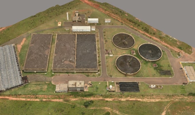

OpenCities Map is a comprehensive geospatial software used to document and model 2D and 3D assets for digital cities. It enables CAD-based mapping workflows within a federated geospatial environment.
The price of OpenCities Map PowerView, OpenCities Map Advanced, and OpenCities Map Ultimate varies per region. While there are various types of licensing available, a common choice is the 12-month practitioner license offered through Bentley’s eStore. When you purchase through the eStore, you get a Virtuoso Subscription which means you get the software AND the training, expert services, and custom mentoring you need to get started quickly.
Processor
Intel® or AMD® processor 1.0 GHz or greater. MicroStation is not supported on a CPU that does not support SSE2
Operating System
Windows 10, Windows 8.1, Windows Server 2016 (64 bit), Windows Server 2012 R2 (64 bit)
Virtualized Environments
Citrix XenApp 7.15 64-bit on Windows Server 2012 R2
Memory
4 GB minimum, 16 GB recommended
Disk Space
25 GB minimum, up to 40 GB depending on additional installations such as companion features and companion products
Connectivity
Internet connectivity is required to use some features and install software pre-requisites.
For the most up-to-date system requirements, visit Bentley Communities.
