Skip to content
Menu
MENU
CLOSE
Login
MY ACCOUNT
Sign In
Lang
US-ENGLISH
DEUTSCH
ESPAÑOL
FRANÇAIS
FRANÇAIS CANADIEN
ITALIANO
POLSKI
PORTUGUÊS BRASILEIRO
中文
日本語
한국어
Menu
MENU
CLOSE
Software
SOFTWARE BY CATEGORY
FEATURED SOFTWARE
SOFTWARE BY CATEGORY
Asset Analytics
Asset Performance
Bridge Design
Building Design
CAD Modeling and Visualization
Digital Construction Delivery
Digital Twins
Geotechnical Engineering
Hydraulics and Hydrology
Mobility Simulation
Offshore Structural Analysis
Pipe Stress and Vessel Analysis
Plant Design
Project Delivery
Rail Design
Reality and Spatial Modeling
Road and Site Design
Structural Analysis and Detailing
Utility and Communication Networks
FEATURED SOFTWARE
Bentley Infrastructure Cloud
MicroStation
ProjectWise
OpenFlows Water
STAAD
SYNCHRO
PLAXIS 2D
PLAXIS 3D
View All Software ❯
About Licensing & Subscriptions ❯
Industries
FEATURED INDUSTRIES
HIGHLIGHTED SOLUTIONS
SOLUTIONS FOR
FEATURED INDUSTRIES
Cities
Energy
Mining
Transportation
Water
HIGHLIGHTED SOLUTIONS
Airport Planning and Coordination
Bridge Monitoring
Dam Monitoring
Electric Distribution Design
Energy Asset Integrated Delivery
Rail Construction Planning
Rail Engineering
Road and Bridge Construction Planning
Road and Bridge Engineering
Tower Analytics and Design
Water Network Monitoring
SOLUTIONS FOR
Engineering Firms
Owner Operators
View All Industries ❯
View All Solutions ❯
Digital Twins
INFRASTRUCTURE DIGITAL TWINS
iTwin SOFTWARE
INFRASTRUCTURE DIGITAL TWINS
Digital Twins
iTwin Platform
iTwin SOFTWARE
iTwin Capture
iTwin IoT
iTwin Experience
Support
SUPPORT
SUBSCRIPTIONS
Support Hub
Knowledge Base
Submit a Support Ticket
Check for Service Outages
Training
SUBSCRIPTIONS
Licensing and Subscriptions
Services
Services Hub
Advisory Services
Data Services
Implementation Services
Company
THE INFRASTRUCTURE ENGINEERING SOFTWARE COMPANY
INVESTMENTS & BUSINESSES
About Us
Blog
Careers
Contact Bentley
Events
Investors
News
Partners
Students & Educators
Sustainability
INVESTMENTS & BUSINESSES
Bentley iTwin Ventures Fund
Cohesive
Seequent, The Bentley Subsurface Company
Shop
Login
SIGN IN
Sign In
Language
US-ENGLISH
DEUTSCH
ESPAÑOL
FRANÇAIS
FRANÇAIS CANADIEN
ITALIANO
POLSKI
PORTUGUÊS BRASILEIRO
中文
日本語
한국어
Home
/
City-A
SUB NAVIGATION
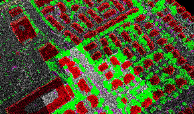
City-A
Detect main components from pointcloud in urban area to support mapping and surveying workflows
Download
Back to AI Detectors
Date
2020-10
Version
1.0
Type
3D Segmentation
Region
North America
Input
Aerial Pointcloud/Mesh
Data for Testing
N/A
Views
Close
20% Off Bentley Software
Deal Ends Friday
Use Coupon Code "THANKS24"
Shop Now
Please wait while you are redirected to the right page...