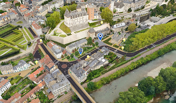
CAPBP initiated a digital twin project for France’s Pau city to simulate and analyze complex urban design and planning issues, then communicate them with all stakeholders. The project involved producing a high-resolution reality mesh for 31 communes covering 370 square kilometers, and integrating the voluminous, multisourced data into a single digital twin accessible to planners, architects, businesses, and citizens. To create their accurate 3D city model and publish it for multiple users to access for a variety of purposes, CAPBP needed a comprehensive, cloud-based digital twin solution.
Using iTwin Capture and OpenCities Planner, CAPBP established an accurate digital twin and urban hub, scalable to multiple workflows and stakeholders. Combined with IoT data, Bentley’s applications optimized data transparency and provided a universal platform to visualize and plan urban projects with greater precision, improving infrastructure management and promoting social sustainability. Working in a cloud-based environment with an immersive digital twin eliminated the production and sharing of static videos, saving almost EUR 200,000 annually, and reduced the cost of accessing city asset information by 95%.
Video Player is loading.
Current Time 0:00
/
Duration 0:00
Loaded: 0%
Stream Type LIVE
Remaining Time -0:00
1x
2x
1.75x
1.5x
1.25x
1x, selected
0.75x
0.5x
Chapters
descriptions off, selected
captions settings, opens captions settings dialog
captions off, selected
This is a modal window.
Beginning of dialog window. Escape will cancel and close the window.
End of dialog window.
This is a modal window. This modal can be closed by pressing the Escape key or activating the close button.
